|
<Previous
Next>
 Canadian website visitor Richard F.
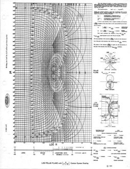
sent me this photo of his "Log Polar Plane" acetate stencil, circa 1958. As a collector
of vintage of science / technical paraphernalia, he ran across this as part of one
of his acquisitions. "Computing Aids" is printed on it. I had never heard of the
log polar plane, but according to the Wikipedia entry, "In mathematics, log-polar
coordinates (or logarithmic polar coordinates) is a coordinate system in two dimensions,
where a point is identified by two numbers, one for the logarithm of the distance
to a certain point, and one for an angle. Log-polar coordinates are closely connected
to polar coordinates, which are usually used to describe domains in the plane with
some sort of rotational symmetry. In areas like harmonic and complex analysis, the
log-polar coordinates are more canonical than polar coordinates." Canadian website visitor Richard F.
sent me this photo of his "Log Polar Plane" acetate stencil, circa 1958. As a collector
of vintage of science / technical paraphernalia, he ran across this as part of one
of his acquisitions. "Computing Aids" is printed on it. I had never heard of the
log polar plane, but according to the Wikipedia entry, "In mathematics, log-polar
coordinates (or logarithmic polar coordinates) is a coordinate system in two dimensions,
where a point is identified by two numbers, one for the logarithm of the distance
to a certain point, and one for an angle. Log-polar coordinates are closely connected
to polar coordinates, which are usually used to describe domains in the plane with
some sort of rotational symmetry. In areas like harmonic and complex analysis, the
log-polar coordinates are more canonical than polar coordinates."
The
David
Young, on the University of Edinburgh website, explains, "Log-polar sampling
is a spatially-variant image representation in which pixel separation increases
linearly with distance from a central point. It provides a way of concentrating
computational resources on regions of interest, whilst retaining low-resolution
information from a wider field of view. Foveal image representations like this are
most useful in the context of active vision systems, where the densely sampled central
region can be directed to pick up the most salient information."

Comparison of photo plotted in Cartesian, Log-Polar, Retinal
coordinates. Institute for Systems and Robotics (ISR|Lisboa) image
Other sources say the log polar plane is convenient for plotting data with rotating
or spiral path, such as a hurricane wind pattern. Also, cone and rod light retina
receptor cells in the eye exhibit a logarithmic spiral pattern, so researchers use
the log polar plane for mapping images in computer vision applications. This page
from the
Institute for Systems and Robotics (ISR|Lisboa) has an interesting representation
of an image plotted in standard Cartesian coordinates, and the equivalent points
plotted on the log polar plane and in retinal coordinates.
As for what Richard's log polar plane stencil would have been used for back in
1958, there was evidently applications in target tracking and targeting for military
purposes that might have been facilitated by such a device. A lot of work was being
done on satellite orbits and rocket trajectories that might have benefitted from
log polar plane plots. As with plotting data on other special coordinate systems
like polar, spherical, and Smith chart planes, deviations from the expected shape
are usually more easily spotted than when represented in Cartesian coordinates.
If you have more information on the log polar plane and why such a stencil would
have been available in 1958, please send me a note.
Posted September 16, 2021
|


 "
"


