|
|||||||||||||
 |
|||||||||||||
Geostationary Orbit Height Calculation |
|||||||||||||
|
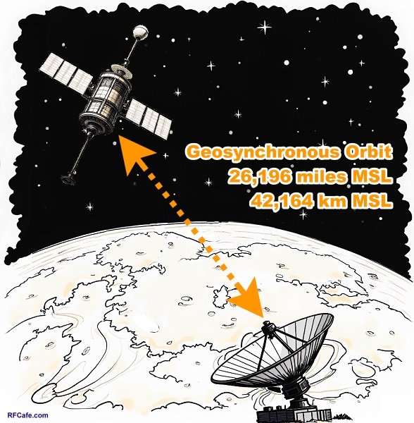
A geostationary orbit is a circular orbit approximately 35,786 kilometers (22,236 miles) above Earth's equator, following the direction of Earth's rotation (see calculations below). At this altitude, an object's orbital period matches Earth's rotational period, causing it to remain fixed relative to a specific point on the surface. This unique characteristic makes geostationary orbits invaluable for applications like telecommunications, weather monitoring, and reconnaissance, as satellites in this orbit provide continuous coverage over designated regions without requiring tracking antennas on the ground. The concept was first proposed by British science fiction writer and futurist Arthur C. Clarke in a 1945 paper titled Extra-Terrestrial Relays: Can Rocket Stations Give Worldwide Radio Coverage?, published in Wireless World magazine. Clarke, who was then a Royal Air Force radar specialist, mathematically demonstrated that an object placed at this specific altitude would maintain a stationary position relative to Earth. He envisioned a network of three such satellites spaced equally around the equator, which would enable global communications coverage - a revolutionary idea at a time when rocketry was still in its infancy and no human-made object had yet reached orbit. Though it would take nearly two decades for technology to catch up to his vision, with the launch of Syncom 3 in 1964 marking the first successful geostationary communications satellite, Clarke's foresight earned him the title of the "father of the communications satellite." The geostationary orbit is sometimes referred to as the "Clarke Orbit" or "Clarke Belt" in his honor, a testament to how a single idea can shape the future of global infrastructure. Geosynchronous Earth Orbit Altitude Calculation The altitude is derived by balancing the gravitational and centripetal forces for an orbit that matches Earth's rotation. A geostationary orbit requires a period (T) of one sidereal day, which is approximately 86,164 seconds. The formula for the orbital radius (r) from Earth's center is: r = 3√[(G * M * T2) / (4 * pi2)] where: G is the gravitational constant (6.67430 x 10⁻¹¹ m3 kg-1
s-2), Calculating step by step: First, compute T2 = 861642 ≈ 7.424 x 10⁹ s2 Then, compute G * M = (6.67430 x 10-11) * (5.972 x 1024) ≈ 3.986 x 10¹⁴ m3 s-2 Multiply them: (3.986 x 1014) * (7.424 x 109) ≈ 2.958 x 1024 m3 Divide by 4 * pi2 (≈ 39.478): 2.958 x 1024 / 39.478 ≈ 7.496 x 10²² m3 Take the cube root: 3√(7.496 x 10²²) ≈ 4.216 x 10⁷ meters, or
Geosynchronous Orbit Altitude wrt Center of Earth: 4.216 x 10⁷ meters, or 42,164 km, or 26,196 miles.
To find altitude above sea level, subtract Earth's average radius (6,378 km):
Geosynchronous Orbit Altitude wrt Mean Sea Level (MSL): 35,786 km, or 22,236 miles.
This calculation shows why all geostationary satellites must be at this specific height above the equator, orbit in any angle relative to the equator or poles. |
|||||||||||||
 |
|||||||||||||
|
|||||||||||||

|
||||||||||||||||||||||||||||||||||||