|
|
|||||||||
| Software: RF Cascade Workbook | RF Symbols for Office | RF Symbols & Stencils for Visio | Espresso Workbook | ||||||||||
|
|||||||||||||||||||||||||||||||
   |
   |
||||||||||||||||||||||||||||||
|
Please Support RF Cafe by purchasing my ridiculously low-priced products, all of which I created. RF & Electronics Symbols for Visio RF & Electronics Symbols for Office RF & Electronics Stencils for Visio T-Shirts, Mugs, Cups, Ball Caps, Mouse Pads These Are Available for Free |
|||||||||||||||||||||||||||||||


Attack Planes Hug Hostile Terrain with New Radar
February 21, 1964 Electronics Magazine

|
February 21, 1964 Electronics ") [Table of Contents] [Table of Contents]
Wax nostalgic about and learn from the history of early electronics. See articles from Electronics, published 1930 - 1988. All copyrights hereby acknowledged. |
 According
to this 1964 article in Electronics magazine, the U.S. Air Force's decision
to build radar systems that would enable low altitude, terrain-following flight
paths for strategic and tactical aircraft was in response to the shooting down of
(Francis) Gary Powers'
U-2 spy craft in 1960. The event made clear that simply flying high over enemy territory
and dropping bombs would not be a reliable strategy since surface-to-air missiles
could reach and destroy aircraft before they got to their targets. Terrain-following
capability on the part of bombers and fighters would add a major element of surprise
since approach paths could be masked until it was too late to take offensive action.
That approach was not without its risks and faults, as made apparent by the
Dr. Strangelove
movie satire that poked fun at the very concept. In the 1964 (same year) hit film
as you might recall, B-52 pilot Major T. J. "King" Kong (Slim Pickens) had been ordered
to drop nukes on a base inside the U.S.S.R. His bomber ended up needing to navigate
through mountains and valleys en route - a feat probably not possible under manual
control. Of course the most famous scene in the movie is Major Kong "yee-hawing"
and waving his cowboy hat as he rides the bomb down.
According
to this 1964 article in Electronics magazine, the U.S. Air Force's decision
to build radar systems that would enable low altitude, terrain-following flight
paths for strategic and tactical aircraft was in response to the shooting down of
(Francis) Gary Powers'
U-2 spy craft in 1960. The event made clear that simply flying high over enemy territory
and dropping bombs would not be a reliable strategy since surface-to-air missiles
could reach and destroy aircraft before they got to their targets. Terrain-following
capability on the part of bombers and fighters would add a major element of surprise
since approach paths could be masked until it was too late to take offensive action.
That approach was not without its risks and faults, as made apparent by the
Dr. Strangelove
movie satire that poked fun at the very concept. In the 1964 (same year) hit film
as you might recall, B-52 pilot Major T. J. "King" Kong (Slim Pickens) had been ordered
to drop nukes on a base inside the U.S.S.R. His bomber ended up needing to navigate
through mountains and valleys en route - a feat probably not possible under manual
control. Of course the most famous scene in the movie is Major Kong "yee-hawing"
and waving his cowboy hat as he rides the bomb down.
Attack Planes Hug Hostile Terrain with New Radar

Advanced capability radar displays the terrain in front of the 650-mph B-52H, enables safe hedge-hopping on bomb runs. Planes operate much below 1,000 feet.
To evade enemy radar, all three services now want terrain-following radar
By John F. Mason
Senior Associate Editor
Harold C. Hood
Regional Editor, Los Angeles
Proof of Soviet ability to knock down high-flying planes (the U-2) forced the U. S. to beef up capability for low-level penetration that would avoid detection by enemy radar. New military planes are being developed to fly ground-hugging missions, and some existing high-altitude aircraft are being retro-fitted to drop down to "tree top" level for the last leg of their approach.
Increased emphasis on this low-altitude strategy is creating greater need for precise instrumentation that enables an aircraft or drone to maintain a desired altitude above the ground and avoid obstructions, regardless of visibility.
Terrain-following radar (TFR), to carry out these missions, is being developed for all three military services. Air Force, which more or less led the search for new techniques, has TFR in the B-52H bomber, and the F-105 fighter. Equipment is being developed for the TFX long-range tactical fighter now being built, and will be developed for any low-altitude penetrator built in the future.
Navy has a number of carrier-based planes capable of low-altitude operations. Those known to have flown with TFR are the A5 Vigilante, the A2F Intruder and the A4D. Navy says the gear is still in R&D.
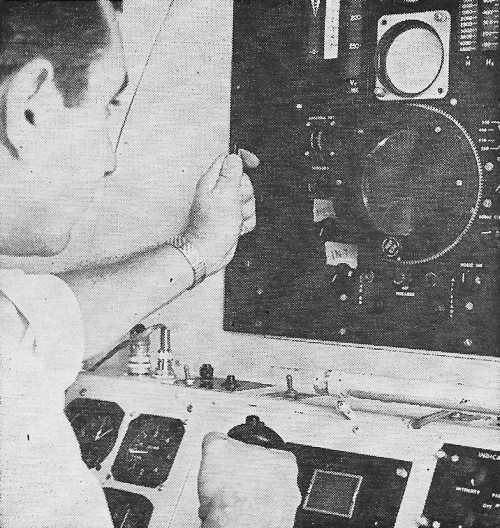
Displays for automatic TFR, built by Autonetics, consists of (center) plan position indication (PPI) and 3-D terrain to give azimuth, range and elevation information. Upper scope tells position of aircraft (circle) in relation to where automatic terrain following command (dot) says it should be.
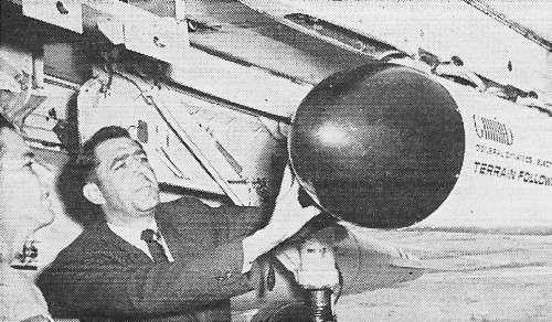
Compact terrain-following radar in pod attached here to Navy's A4C Skyhawk has also been tested by USAF.
Army has an active program going for the Mohawk surveillance plane and a healthy interest in the complicated problem of getting TFR for helicopters.
Cornell Aeronautical Laboratory (CAL) has been an important research and development arm of the military on TFR for 10 years.
CAL's Autoflite system was designed, fabricated and flight tested under sponsorship of USAF's Aeronautical Systems Division. Industry has been active in the field for the past four or five years and will be more active in the future.
Equipment - Terrain following refers to vertical change in flight direction - going up or down to maintain a constant altitude above the ground. Terrain avoidance implies ability to turn left or right to avoid obstructions or to take advantage of the hills that protect a valley. The more sophisticated units provide both. Equipment may be manual, automatic, or both. Other functions sometimes connected with TFR are air-to-air search and ground mapping.
Texas Instruments - Active in the field for several years, TI is known to be working on three important TFR projects: $5-million subcontract from McDonnell for development work on a low-altitude TFR system for the RF4C - USAF's reconnaissance model of McDonnell's Phantom II fighter; subcontract with General Dynamics for equipment for the F-111 (TFX); and a contract with the Army Electronics Command for an advanced system for Army's Mohawk surveillance aircraft.
Autonetics-North American's Autonetic's division has produced TFR for the F-105F Thunderchiefs, the German Air Force F104G Starfighters, and - with IBM and AC Spark Plug-equipment for the B-52H.
The firm is developing a series of terrain-oriented radars for possible use on a number of future military aircraft. For the VAX program to develop a triservice attack aircraft, a multi-mode radar with automatic terrain-following capability is proposed. Beyond VAX, Autonetics is working on the XR-45, a system that will use thin-film microcircuits and stress reliability. Meantime-before-failure (mtbf) goal for the entire multimode radar system is from 300 to 500 hours; mtbf for the automatic terrain-following mode will be from 2,000 to 4,000 hours.
Autonetics's emphasis on solid-state components is shifting to microminiature techniques. Except for the transmitter and power supply the whole system is microminiaturized. Thin-film is used for the high frequencies. Integrated circuits are as yet of little use anywhere in the system because of the high frequencies used.
NASARR System - The firm has recently demonstrated their modified R-14 NASARR (North American Search and Ranging Radar), described as the first system with simultaneous automatic terrain-following, manual terrain-following and manual terrain-avoidance capabilities. The radar uses a data processor with solid-state electronic circuits.
The automatic terrain-following mode guides the plane at a prescribed altitude while manual terrain avoidance gives the pilot a broad radar view of the terrain ahead, permitting selection of flight-path alternatives. Automatic terrain-following signals are provided by an altimeter in level areas, and by the forward-looking radar over hills or mountains.
The radar has four displays - plan position indication (PPI), three-dimensional terrain, elevation-angle, and manual terrain following.
The PPI and 3-D displays are combined on one tube, giving azimuth and range position in relation to mountains. As a mountain comes into range. it appears on the azimuth-angle scope. With the aid of the manual terrain-following display, the pilot is able to verify automatic terrain following or fly manually over the mountain.
General Dynamics/Electronics - GD/E built the radar portion of the navigation system for Navy's A5 (A3J) Vigilante. The radar is part of the REINS (radar-equipped inertial navigation system) built by Autonetics. The system is used for both low and high-level penetration, and for launching air-to-ground missiles.
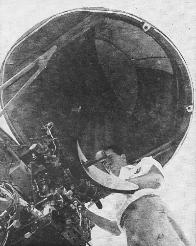
Antenna dish permits 90-deg azimuth scan and wide elevation coverage in automatic TFR unit built by Autonetics.
GD/E has checked out a compact TFR unit on a B-25 for more than 150 hours at 400 feet, and on a B-26 for more than 50 hours. The basic system consists of an on-bore-sight radar with a non-scanning antenna 8.3 inches in diameter, and a built-in electronic analog computer. A pilot display and automatic pitch control signals are provided.
The radar is housed in a pod the size of a standard 250-pound bomb, mounted under the wing or in the nose of an aircraft or drone. It weighs 40 pounds, occupies 1/2 cubic foot.
The Ku-band radar detects small individual objects within a continually moving field a tenth of a mile deep at a selected distance ahead. Terrain information from the antenna is fed to the small analog computer where it is correlated with flight characteristics and altimeter input. Continuous flight instructions are presented to the pilot through a simple meter or to the automatic pilot. No radar scope presentation is required. Instrumentation may be simplified further by combining a climb-and-descend indicator with the attitude indicator.
For safety, an r-f signal is continually fed into the waveguide feed and then through the system. If a failure occurs while the pilot is flying manually, a warning light turns on. Failure during automatic flight results in an automatic climb command to the autopilot.
GD/E's system was developed with company funds, It differs from most other systems in that it uses a fixed beam rather than vertical scanning. It also depends more heavily on input from an altimeter than do other systems. The fixed beam is directed with a fixed depression angle. It is stabilized by servoing it to the angle-of-attack data.
Other Producers - Under an "integrated approach," Hughes is incorporating air-to-air search and ground mapping along with TFR. Hughes has been under contract to improve a prototype system built at the Navy Avionic Facility in Indianapolis (NAFI). The Naval Ordinance Test Facility, China Lake, Calif. is also working on TFR. Other firms include Raytheon, Emerson Electric and Norden.

Copyright: 1996 - 2026 |
About RF Cafe RF Cafe began life in 1996 as "RF Tools" in an AOL screen name web space totaling 2 MB. Its primary purpose was to provide me with ready access to commonly needed formulas and reference material while performing my work as an RF system and circuit design engineer. The World Wide Web (Internet) was largely an unknown entity at the time and bandwidth was a scarce commodity. Dial-up modems blazed along at 14.4 kbps while tying up your telephone line, and a lady's voice announced "You've Got Mail" when a new message arrived... |
Copyright 1996 - 2026 All trademarks, copyrights, patents, and other rights of ownership to images
and text used on the RF Cafe website are hereby acknowledge My Hobby Website: My Daughter's Website: |