Radar Plots the Invasion |
|||
D-Day occurred on June 6, 1944. It was the day that Allied forces stormed the French coastline with overwhelming numbers of battleships, landing craft, bombers, fighters, and personnel. It broke the German stronghold on mainland Europe and marked the beginning of the end of Hitler's dominion. These photos are the first official releases of radar imagery before and during the D-Day* invasion at Normandy. Pre-invasion reconnaissance radar plots show a sparsely populated coastline and English Channel. White areas that indicate radar targets were concentrated mainly in city regions. On the day of the invasion, white returns nearly saturate the displays due to the incredible presence of all the aforementioned war machine elements. Even the soldiers' presence contributed to the return because of all the metallic hardware being carried - guns, ammo, radios, helmets, bayonets, canteens, etc. Less than a year later, on May 8, 1945, the Western world was celebrating what is now known as V-E Day (Victory in Europe). Thanks to Terry W. for providing this article. Radar Plots the Invasion By Eugene Mason Presenting for the first time historical radar photos of the Normandy beachhead invasion. Radar has proven to be the greatest technical development of this war.
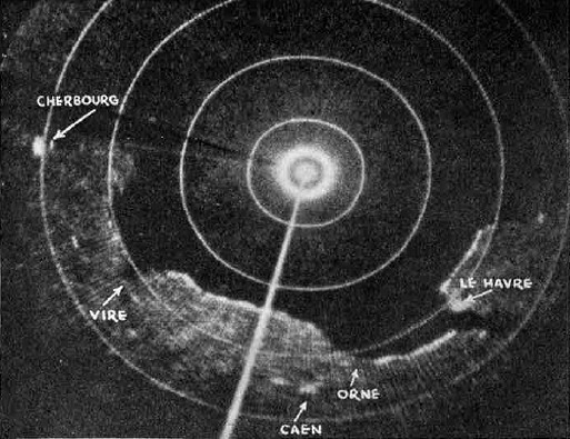
Radar's most extensive use is to portray sea and ground formations far beneath high-altitude bombers and reconnaissance planes. Scanning the earth with its electronic beam, radar draws accurate maps of the land and sea beneath the plane - despite darkness, clouds, or rain. Shown here, for the first time, are actual pictures seen by radar operators in their oscilloscopes, miles above the French coast before and during the European invasion. Every dot or blur of white has some significance in understanding a radar scope picture, because each dot of white indicates an object on the ground reflecting the radar pulses. Thus large cities show up brighter than the surrounding countryside. White dots in the English Channel are boats, ships, or low-flying aircraft. Small dots visible inland usually indicate man-made structures. The brilliant white blotch in the center of these pictures shows the position of the plane when the photograph was taken. Concentric circles indicate the range from the plane. The Normandy beaches looked quiet and peaceful (Fig. 1) during a pre-invasion reconnaissance flight. The cities of Le Havre and Cherbourg are clearly visible in the scope. And the characteristic French seacoast is strongly etched. The same beaches on D-Day (Fig. 2) look much different. Every dot on the oscilloscope represents one or more invasion craft in the Channel. A few of the white blobs represent planes flying low over the water. Seen from a height of many miles, the radar-equipped plane was about 35 miles from the French coast, its position indicated by the brilliant center spot. Strong elements of the invasion fleet are massed just off shore. But in every direction can be seen the great mass of sea and air power thrown into the D-Day offensive. The radar-equipped plane has passed over the invasion fleet (Fig. 3) and, at a lower altitude, is about to cross the coastline. The plane, on a bombing mission ahead of the newly established bridgehead, will use radar to locate strategic military objectives. Even though the pilot and bombardier can see nothing, the radar operator can tell them where they are. Before crossing the coastline, the radar operator flips a switch on his set to obtain a greatly magnified picture (Fig. 4) of the actual bridge-head. The many white dots and blurs - though difficult to distinguish near the center of the scope - are clearly discernible as invasion barges, boats, and ships. These are historic pictures - tiny white blobs of light on the face of an oscilloscope that attest to the might of Allied sea and air power.
Fig. 2 - Same beaches on D-Day as those shown in Fig. 1. Plane has moved to within thirty-five miles of the coast. Its position indicated by bright spot in center of scope. Invasion fleet (smaller blobs and grains) is clearly visible massed just off shore. Fig. 3 (center). Even though pilot and bombardier can see nothing. Radar operators can tell them just where they are and when to drop their bombs. The photograph shows that the plane has lust passed over the invasion fleet and is about to cross the coastline. Fig. 4 (right). Radar operator has turned a switch to obtain a magnified exact picture of a small part of the coastline.
* The U.S. Army website historical page is not linked because the historical revisions dictated by rampant political correctness now makes most "official" information unreliable. It might not be untruthful, but relevant information has often been scrubbed.
Posted June 6, 2021 |
|||