Aerial "Private Eye" Traces TV Signals |
||
Anytime I see an airplane in a photograph, my interest is immediately piqued to learn the story behind it - sort of like with the "MPATI - Its Problems & Solutions" feature in the May 1963 edition of Electronics World magazine. This "Aerial 'Private Eye' Traces TV Signals" story also involves airplanes and television broadcasting, albeit in a completely different way. A couple enterprising broadcast engineers created a company called Tele−Beam Industries, in Napa, California, that measured and mapped TV signal strength in the region surrounding transmission towers to provide the stations with information useful in marketing and radiation characteristic planning. Signal strength measurements were made from some starting altitude down to within 100 feet of the ground, in 100 foot increments, and was repeated in increments of 10° of azimuth, radially from the transmitting antenna, and a distances of 1, 3, 10, and 40 miles out. That added up to many thousands of measurements, and might have been one of the first such efforts anywhere to map the 3D signal strength over such a large area. Unfortunately, no example of the resulting 3D chart is provided in the story.
Aerial "Private Eye" Traces TV Signals
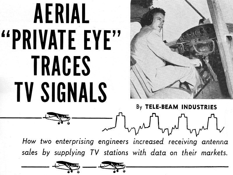
Pilot-General Manager Ralph Bykerk at the controls. By Tele-Beam Industries How two enterprising engineers increased receiving antenna sales by supplying TV stations with data on their markets. What happens to television signals when they leave their home antenna high atop a tower and find themselves on their own in a large open space, full of mysterious waves and cross currents? Why are some signals received clear as life 75 miles away while others arrive pale, weak, and ghostlike on nearby screens? To try and get the answers to these old-as-video questions, a team of TV troubleshooters has taken to the air and actually tracks down signals as they are being telecast. Their findings are proving of great value to television stations, and to jobbers and dealers, as well as to their own business, which is the manufacture of antennas and TV accessories. The airborne team is composed of Ralph O. Bykerk, owner, and Ray J. Mitchell, sales manager, of Tele-Beam Industries, Napa, California - both radio-TV engineers. The air survey was the last resort in a series of tests to find out why, in areas equidistant from telecasting stations and with the same terrain, they would find one town with high signal levels, while in the other direction from the station there was barely enough signal to give a reading on a field strength meter.
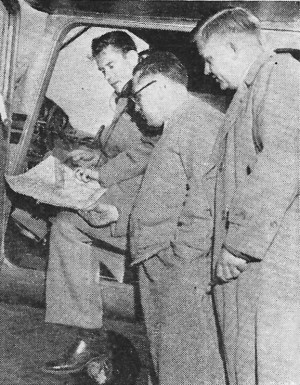
Bykerk and Ray Mitchell go over findings with John Kelley, KTNT-TV's assistant engineer. First, Tele-Beam engineers designed their antennas to go higher in the air to get difficult signals, but this wasn't the answer. Then they mounted 50-foot masts on their station wagons, with antennas, field strength measuring equipment, and even the full equipment of a local amateur station, to make radiation patterns of the TV stations. On a survey in the Puget Sound area they used a boat to fill in the area not accessible by vehicle. Unusual radiation patterns were found, and the great extent of terrain effect was realized, but still the engineers were not satisfied. Then somebody got a brain-wave - why not test the signals in the air, using the Cessna 170 which the firm maintains for business transportation? Tele-Beam's technical staff swarmed over the aircraft making and spacing antennas, checking ignition noise, static effect, and all the complications of air-craft radio. With completion of the one-meter folded antenna spaced properly under the fuselage, field strength meter, and power converter, the Tele-Beam pioneers took off into the blue. While in the air, CAA was contacted regarding the flight plan, and the altitude and pattern of flight. Eventually special permission was obtained for aircraft, pilot, and passengers, and a whole new field was opened. The company's aerial survey service has, since its first flight over a year ago, proved of great value to many West Coast TV stations in programming for their areas as well as the company. The firm has learned what merchandise to recommend in a given region in the reception area of any TV station tested, and both the company and its dealers can be pretty sure it will stay sold. These aerial surveys are made gratis at the request of TV stations. Wholesalers and dealers may participate in the surveys at the discretion of the station. Here's how an aerial survey would work on hypothetical station USA-TV, channel 10, which is located at an altitude of 904 feet with a 500-foot tower and a 55-foot, 12-bay turnstile - total, 1432 feet above sea level (but to be exact, the pilot flies a course straight toward the center of the turnstile and checks the altimeter). Disregarding the terrain below, which sometimes rises to 1350 feet or falls off to 600 feet, the pilot flies out the time required at his rate of speed, to be five miles from the tower. Prior to take-off, aeronautical and topographical maps have been checked to set up local identification marks such as water towers, grain bins, small towns, or even rifle ranges and golf courses. Starting at the north of the station, or at zero degrees, the pilot flies the five mile circle, calling out every ten degrees - 350, 340, 330, etc. Readings are taken at each of these ten degree positions while flying in concentric circles. The second time around, the ground effect is observed and charted. Similar readings are taken at distances of one mile, three miles, 10 miles, and, many times, at 40 miles. Then, when the plane is back on the ground, polar plots are drawn. These polar plots are superimposed in order to develop the final plot or radiation pattern of the station. Actual deviation has been found to be as much as 14 db, while other stations were found to conform very well to design. Vertical plots are made every 90°, or if the station's chief engineer desires, every 45°, this being done by going to 2000 feet above the center of the turnstile - or in the case of station USA-TV - to an altitude of 3,350 feet. At this height the plane turns toward the station and dives earthward at a rate of 2000-feet-per-minute (until the surveyors can almost see the barbs of the barbed wire fences), all the time reading the meter every 100 feet. All of the information gathered on these aerial survey flights is plotted both on polar paper and aeronautical and topographical maps, so that just what and where the station is transmitting can be checked. In some cases the signals have been found to be going directly skyward! In addition, the answers to deep slots, strong lobes, noding effect, and many of the other problems of reception are easily ascertained. Irregularities of terrain in particular and surrounding areas create special problems in reception, and weather also has an important effect. Moisture laden clouds tend to bend waves and cause ghosts. Distorted pictures, interference, and weak signals are often caused by such varied things as defective fluorescent lamps, power line noise, auto ignition, welding machines, and aircraft engines. The type of antenna, its height and position are of the utmost importance, depending upon location of the set. Sometimes moving an antenna only six inches on the roof gives almost 100% improvement in performance. Weeks of flying over an area, testing signal strength and patterns of TV stations - measuring radiation in both vertical and horizontal planes - produced data leading to the development of improved antennas specially designed for the area. Findings are reported in full to the TV stations, jobbers, dealers, and technicians in the territory as a preliminary to marketing the antenna. The station is able to effectively analyze the performance of its radiating system and programs accordingly - saving the considerable time it would have taken the station to accomplish the same results. Jobbers have a certain knowledge of what to merchandise in areas surveyed, dealers can get maximum results from their efforts, and set owners are more satisfied with their TV reception - all because a couple of fellows wanted to get enough information to build a much better antenna. Tele-Beam Industries, 6th & Soscol Avenue, Napa, California.
Posted May 8, 2020 |
||