Electronic Navigator |
|
Here is yet another report on the wonders of radar technology as the country was coming out of the throes of war. As mentioned before, radar was a highly classified science during World War II, and it is credited, along with the Douglas C-47 and the Jeep (two of General Eisenhower's four "Tools of Victory") for being a major contributor to Allied success. At the beginning of war, when radar operators in Hawaii were misinterpreting squadrons of attacking Japanese aircraft for a flight of B-1-7 bombers being ferried from the mainland, radar displays were essentially x-y axis oscilloscopes indicating range and signal strength. By the end of the war, the antenna-synchronized rotating plan position indicator (PPI) format had been introduced, providing a much more useful format for determining target situations. Radar was adapted for shipboard use as well. Soon after the war, commercial uses for radar were quickly designed and installed. See also "Radar - Secret Weapon No. 1." Electronic Navigator
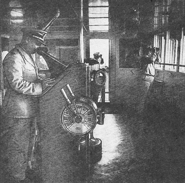
Using the Electronic Navigator in a demonstration aboard the "American Mariner." More important to the safety and speed of navigation than any other single invention is this new application of radar. First of the many peace-time applications of radar is an "electronic navigator" which can detect through darkness, fog and storm the position of any above-water obstacles, lighthouses, shorelines or other ships. The instrument, which works along the lines of the Plan Position Indicator described elsewhere in this issue, is so sensitive that it can detect metal objects as small as ordinary buoys. A ship, instead of lying outside a harbor for days, waiting for fog to lift, can navigate up the channel by the buoys on each side, meanwhile "seeing" any other craft in the same area. Dr. W. R. G. Baker, General Electric vice president in charge of electronics, who had much to do with the development of television in its present form, predicts that the new device will revolutionize "thick weather" navigation, providing the mariner with an instrument to plot a safe course, even though his normal visibility is strongly limited by natural conditions. A working demonstration of the apparatus, held recently in Long Island Sound, showed how, in the dead of night, it is possible for a ship to operate safely and accurately through any kind of thickened overcast condition, with the radar mechanism giving the ship's navigator a bird's-eye view of the surrounding waters, his own ship being always in the center of the field. During the demonstration in the waters off Long Island, such objects as other ships, channel markers, lighthouses and land masses were shown in their relative positions, and both distance and bearing were automatically plotted on the face of the viewing screen. The distance of objects from the ship was shown in true proportion, being measured by a series of concentric "marker rings" electronically superimposed on the picture screen. According to General Electric engineers, the measurement of distance so given is accurate to the point of one percent.
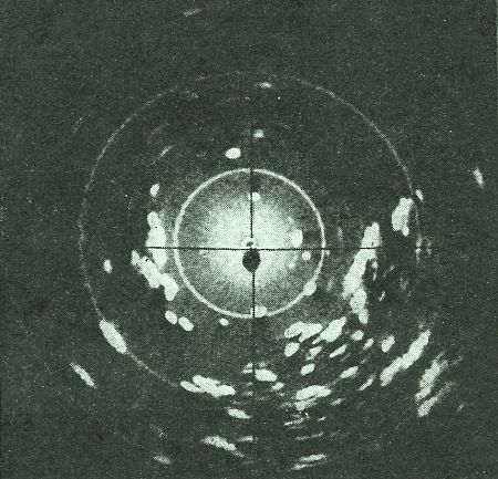
Map of the area on the screen of the cathode-ray tube, as it appears to the pilot. Photos courtesy General Electric Co. Basis of the "electronic navigator," is a rotating antenna, located on the top deck of the snip and analogous to a searchlight, in that it sends out beams to locate obstacles in the ship's path. The difference, however, is that beams from the radar antenna, which are actually powerful radio microwaves, are capable of penetrating fog or any other atmospheric conditions without hindrance. They are sent out as "pulses" or surges of extremely short duration and at a very rapid rate. As the radar waves locate an obstacle in the surrounding waters, they bounce off and are scattered, no matter of what material the object is. Some of these echoes - or scattered waves - will return to the rotating antenna, which also acts as the receiving antenna during the time intervals between the outgoing pulses. After being amplified, these echoes are made to appear as bright spots on the face of a cathode ray tube, which is somewhat similar to a television screen tube. The image thus formed gives the operator a "radar picture" of the obstacle, and the marker rings tell him how. far away it is. By controlling internal circuits, the operator may change the scale of the field to cover either a 2-, 6-, or 30-mile radius. Thus, when a ship is sailing in the open sea, the operator will use the 30-mile range until an object approaches to within 6 miles. Then, by turning a knob on his radar set he is immediately presented with a large; scale chart, the outer radius of which is 6 miles. For very close work another turn of the knob provides a 2-mile radius chart on which objects may be observed down to about 200 yards. Radar waves sent out, from the ship's antenna travel with the speed of light - 186,000 miles per second - and therefore require only about a millionth of a second to make a round trip to an object 200 yards away. Since the measure of distance to an obstacle is given with extreme accuracy by the marker circles, the system must be able to measure time down to one hundred-millionth of a second. In 1943, more than four million gross tons of cargo space were lost on the Great Lakes alone as the result of fog. Out of this, two million tons were lost through serious and hitherto unavoidable accidents such as collisions and groundings. The major part of lost cargo space was caused by fog delays. In 1943, as many as 100 boats at a time were fog-bound at the Soo Locks. Adverse conditions such as these sometimes delayed vessels as much as 30 hours at a time. The new electronic device will permit the lake navigator to maneuver and direct his ship with utmost safety - in the thickest weather, in the heaviest storm and static, in darkness - or in any combination of all these. Under any adverse weather condition, it will enable the navigator to locate ships, buoys, icebergs, derelicts, and shore lines. It will help him locate river mouths, break-waters, docks and bridges. During storm and blizzard, it will enable him to hug a lee shore and proceed safely, even at times when the time-honored method of echoing the sound of ship's whistle against shore becomes ineffective. The cramped quarters, short runs, and - on the Great Lakes - frequent fogs "or storms, make the electronic navigator even more valuable for inland navigation than for deep-water shipping. Despite the complexity of circuits within the radar system, which such accurate timing makes necessary, demonstrators declared that sets are as easy to operate as a. large home radio receiver. A few minutes instruction will enable an operator to grasp the fundamentals of operation, and in a few hours of practice he can learn safe recognition of various types of objects, as well as their bearing with respect to the course and position of his own ship.
Posted August 5, 2021 |
|